Most will overlook the third Welland Canal, and with good reason, of all the canals it is the least interesting, the least preserved and is, to be honest, boring. The Third Canal came at a moment of transition, a move from a colonial province to a world power for Canada. Plus the end of the age of sail. The Second Canal by the 1850s had just completed their depth increase to put it in line with the improved navigation along the St. Lawerence, Detroit, and St. Clair Rivers. But the increased depth, increased size in ships only showed the need for an improved water source along the second Canal. Not to mention the continued drive for water power for the advanced industrial presence along the second Canal. And while the Canal clamoured for attention, the Canadian Government of the 1860s had bigger fish to fry. Between the American Civil War, Fenian Raids, and their internal political turmoil with the drive towards Confederation the Welland Canal could be but on the back burner. At least the Canal still functioned, and the shipyards along her banks provided canallers who easily fit through the locks. When the Dominion of Canada came into creation in 1867, the Welland Canal ended up in the control of the Federal Government of Ottawa, not the Ontario provincial government. It wouldn’t be until 1870 that the need to update the Canal came up to Parliament and a commission was struck. The commission investigated not only the possibility to update the current Canal. Still, it studied the creation of a new canal route in a whole different part of the province that could link Lake Ontario to the Northern Great Lakes. It made little sense to move the route of the Canal as much of Canadian trade took place upon the US/Canada border not to mention the US moving towards a more railroad centric and the Welland Canal corridor provided plenty of existing infrastructure. It would be an update to the Welland Canal that the commission presented to the Federal Government in 1871.
Minolta Maxxum 9 – Minolta Maxxum AF 28mm 1:2.8 – Kodak Tri-X 400 @ ASA-400 – Kodak D-76 (1+1) 9:45 @ 20C
Minolta Maxxum 9 – Minolta Maxxum AF 28-135mm 1:4-4.5 – Kodak Tri-X 400 @ ASA-400 – Kodak D-76 (1+1) 9:45 @ 20C
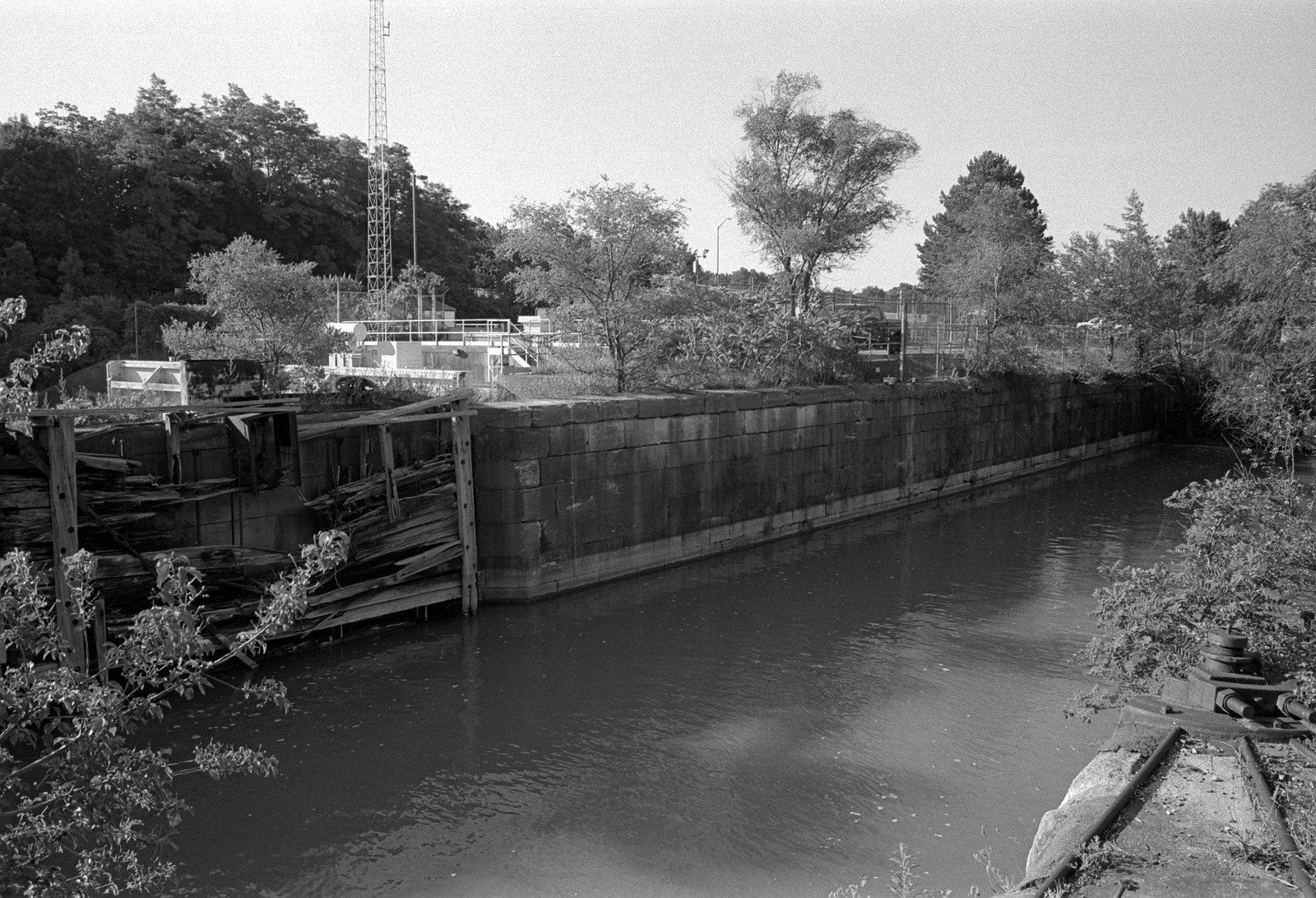
The problem with the second Canal came down to ships. The first Canal came when sailing vessels were the norm; by the second side-padel steamships were starting to become a common sight. By the later half of the Century, the age of sail was coming to a close and the new steamships now travelling the global and local trade routes were larger, heavier, and driven by propellers. These new ships could travel the Canal under their power, no longer needing teams of animals and guides to tow them along the paths along the canal banks. You’ll notice that some of the roads that run along the Canal are called “Tow Path” it’s a throwback to the old methods of moving ships. However, it also required that a far more direct route be plotted for the Canal, as larger ships would have a more challenging time to navigate the winding natural waterways that the first and second canals used. Engineers could reuse the canal route above the Escarpment, but below a new artificial channel would have to be cut. The new channel was plotted to the south-east of St. Catharines bypassing the downtown and the historic canal valley. They were creating an artificial channel allowed for constant width and depth. Engineering specified a width 31 meters (100 feet) and a depth of 4 meters (12 feet), locks were 82 meters (270 feet) long and 14 meters (45 feet) wide and kept the same depth. Lock walls were again built of stone with iron infrastructure and wooden gates. The locks were also designed to have the syphons and drain in the lock walls to allow faster filling and draining and a wooden ‘floor’ to mitigate damage to the hulls. Officially 1872 marked the start of the new canal’s construction. But it would not be until 1874 that all the contracts were awarded. Some 3,000 workers were employed to handle the manual labour and operate machines. Yes, steam-driven pumps, diggers, engines, and drills even heavy diggers were employed. In addition to digging the new trench from Port Dalhousie to the Escarpment and the cutting of the new mountain locks up the Escarpment the harbours at Port Dalhousie and Port Colborne needed expansion to accommodate the larger ships. Work also had to be done to increase the size of the deep cut running from the top of the Escarpment to Port Colborne. The Government also promised to build new bridges to carry roads and rails over the new Canal as many existing bridges were in disrepair. But all was not easy; the new canal channel saw many farms destroyed and even a scenic waterfall that was popular among residents. The whole new route prevented the use of the old Canal to move workers and supplies; instead, the railroad provided the movement. Both Great Western and Welland Railroad were used with significant effect. Even during the construction, the Government increased the canal depth to 5 meters, and while most of the canal locks were dug to the original depth, workers followed expanding the depth. The Canal opened officially in 1881, and by 1887 the final depth had been achieved.

Minolta Maxxum 9 – Minolta Maxxum AF 100mm 1:2.8 MACRO – Kodak Tri-X 400 @ ASA-400 – Kodak D-76 (1+1) 9:45 @ 20C
Minolta Maxxum 9 – Minolta Maxxum AF 28mm 1:2.8 – Kodak Tri-X 400 @ ASA-400 – Kodak D-76 (1+1) 9:45 @ 20C
Upon opening the new Canal was nowhere close to providing a directly straight line between Port Dalhousie and Port Colborne. However, it had reduced not only the length of the Canal but also the number of locks a ship had to use to transit across the Peninsula, forty-three kilometres and twenty-six locks. The number of locks was reduced as plenty of effort had been poured into levelling the new artificial channels, and the locks at the two terminuses were used primarily for gatekeeping purposes rather than raising and lowering ships. With ship traffic moved to the new Canal, some sections of the old second Canal were closed to traffic, namely the old mountain locks between St. Catharines through Merritton and ending in Thorold. The two old sections of the Deep Cut were now merged into the new Canal’s cut. A horse-drawn streetcar service became a new means of moving between the industrial cores of the Canal, service started in 1876, and when a small hydro-electric generator began operating at Lock 12 of the second Canal in 1887, the streetcars switched to working on electricity instead. That would be a significant shift. The new Canal would not have any industry using its water to power factories. Water coming into the Canal now came from Lake Erie and by the end of the Century was being shared between the new hydro-electric generating stations being built at Niagara Falls and DeCew Falls. The introduction of electrical generation on the Canal (both the Second and Third) brought new and larger industries. In 1888 Canada Hair Cloth opened in downtown St. Catharines it’s generators being powered by the Second Canal, and in 1890 Maple Leaf Rubber in Port Dalhousie produced enough power to provide electricity for streetlights. And the ability to carry heavier ships and therefore heavier cargo only helped build the industrial base through St. Catharines, Merritton, Thorold, and even Welland began to expand thanks to the discovery of large quantities of natural gas. Communities would build better bridges over the older canal channels as road traffic and railroad traffic improved. Even ships could move easier across the Great Lakes, by the end of the 19th Century a ship could travel from the Gulf of St. Lawrence to Lake Superior using a network of fifty-three locks. The Third Canal had turned the Welland Canal from a local solution for industrial power into a central trade corridor.
Minolta Maxxum 9 – Minolta Maxxum AF 28-135mm 1:4-4.5 – Kodak Tri-X 400 @ ASA-400 – Kodak D-76 (1+1) 9:45 @ 20C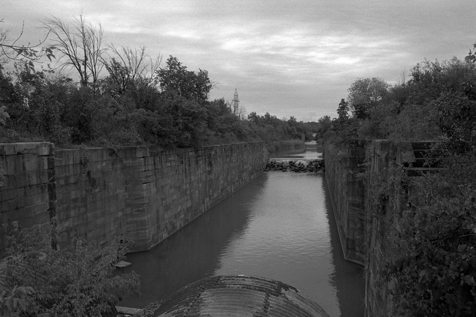
Minolta Maxxum 9 – Minolta Maxxum AF 28-135mm 1:4-4.5 – Kodak Tri-X 400 @ ASA-400 – Kodak D-76 (1+1) 9:45 @ 20C
But the Canal’s expansion and encouragement of heavier industry would turn against itself as bigger and heavier ships began to operate on the Great Lakes. These vessels soon outgrew the Third Canal, and by the first years of the 20th Century, it was becoming clear that a new Canal would be needed. The Canal also offered up a tempting target for terror. Luke Dillion, an American and member of the Irish independence group, Clan-Na-Gael, targeted Lock 24 hoping to disable an essential lock in the Mountain Lock system. The effort failed and Dillion and two conspirators arrested thanks to a local woman. The new Century had changed the canal scene, tow teams were no longer needed in large numbers, while some sailing vessels still operated as late as 1915, steamships moved through the Canal under their power. The route change reduced the need for hospitality services in the communities. Small mills were now a thing of the past, and larger and heavier industry moved in foundries, factories, and shipyards operated non-stop. Of course, the Third Canal’s days were numbered as efforts began to plot a new route which would change the Lake Ontario terminus to a new planned community of Port Weller in 1912. The Third Canal saw a brief respite when work on the new Canal stopped in 1914 as the Canadian economy shifted to a war footing as the Great War raged in Europe. And even in the war, the Third Canal played its role as the factories in Welland, Merritton, Thorold, and St. Catharines provided everything from parts to the material to guns and ammunition. But once the war ended construction on the new Canal restarted. The Third Canal survived until 1935 when navigation onto the remains of the second Canal and the third Canal closed off, this time for good.

Minolta Maxxum 9 – Minolta Maxxum AF 28mm 1:2.8 – Kodak Tri-X 400 @ ASA-400 – Kodak D-76 (1+1) 9:45 @ 20C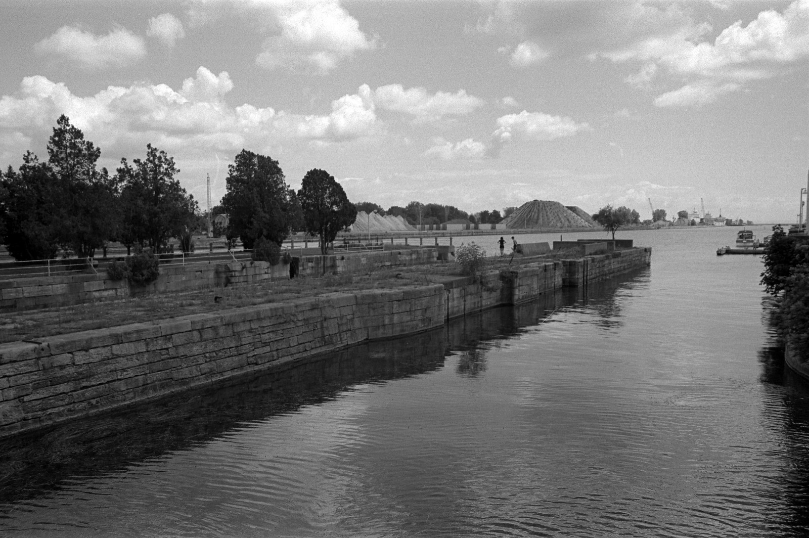
Minolta Maxxum 9 – Minolta Maxxum AF 28mm 1:2.8 – Kodak Tri-X 400 @ ASA-400 – Kodak D-76 (1+1) 9:45 @ 20C
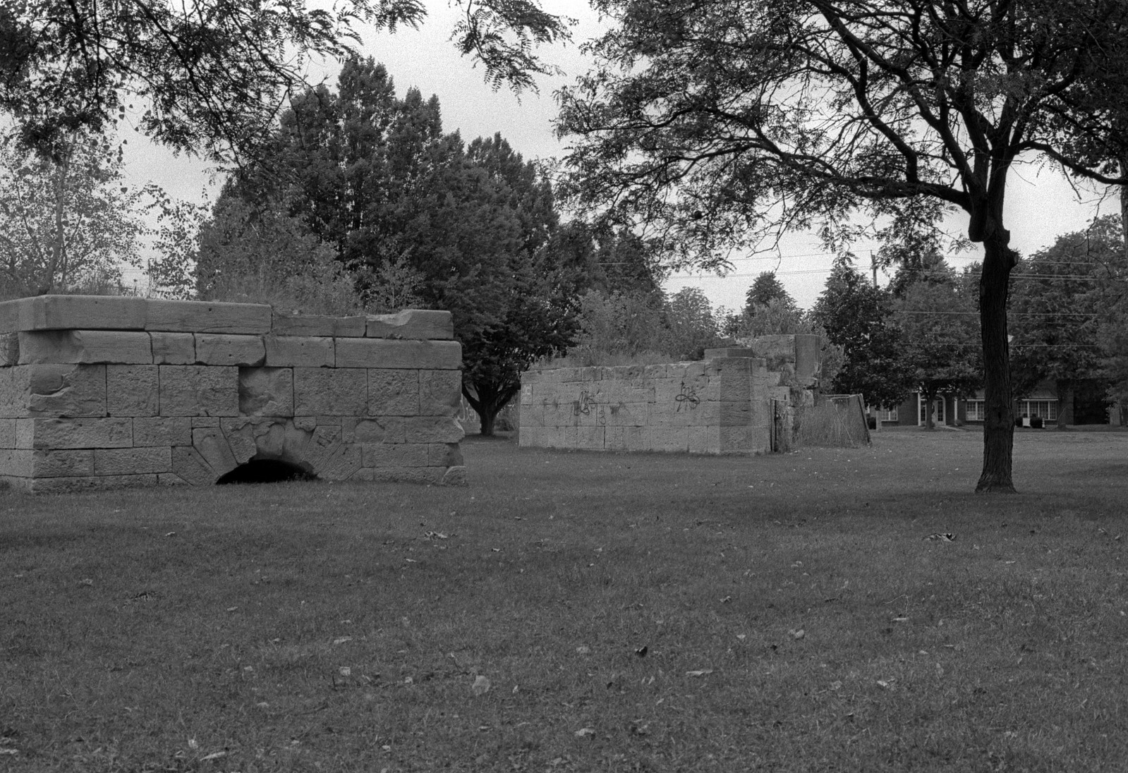
The Third Canal quickly disappeared under the drive to expand. The channel below the Escarpment had put a serious crimp in the plans for further urban growth to St. Catharines, and during the 1950s in the post-war boom the old channel was filled in, and much of the lock infrastructure was also lost. Above the Canal, the surviving channels of the third Canal were quickly taken over by the even larger forth Canal. And yet, today thanks to the efforts of many there is still a decent showing by the Third Canal. The largest selection of locks is the Mountain Locks, although access to see them is time-consuming. There is also the question of legality as the locks are bounded by the Fourth Canal and General Motor’s St. Catherine’s plant and are technically on Canal property. Security will either leave you alone or get you on trespassing. When I visited the Mountain Locks, I stayed on the public road as there were a group of explorers who were being handed out tickets by local Police having been caught by Seaway Security. However, you can legally see Locks 1, 2, and 4 all on public property in St. Catharines. Lock 1 is located in Port Dalhousie although a little outside the downtown, Lock 2 is located in Jaycees Park along with a historical plaque. Lock 4 is behind Bill Burgoyne Memorial Arena. At Port Colborne, the gate lock is still present next to the old Second Canal lock and remains in use as part of Lock 8 on the fourth Canal. Despite being often left behind and out of the limelight, the Third Canal played one of the most critical roles in the history of the Canal since Merritt’s channel. It put Ontario on the map as a major industrial centre and a significant trade route. It brought Canada out of the colonial era and into the modern age.
Written With Files From
Jackson, John N. The Welland Canals and Their Communities: Engineering, Industrial, and Urban Transformation. University of Toronto Press, 1997.
Styran, Roberta M., and Robert R. Taylor. This Colossal Project: Building the Welland Ship Canal, 1913-1932. McGill-Queen’s University Press, 2016.
Styran, Roberta M., and Robert R. Taylor. This Great National Object: Building the Nineteenth-Century Welland Canals. McGill-Queen’s University Press, 2012.
Styran, Roberta McAfee, and Robert R. Taylor. Mr. Merritt’s Ditch: a Welland Canals Album. Boston Mills Press, 1992.
Jackson, John N., and Fred A. Addis. The Welland Canals: a Comprehensive Guide. Welland Canal Foundation, 1982.
Styran, Roberta M, et al. The Welland Canals: the Growth of Mr. Merritt’s Ditch. Boston Mills Press, 1988.