Out of all communities formed along the Welland Canal, both large and small, the ones that are most important to the Canal are the ports. It’s easy to tell which communities along the Canal remain or are former terminuses or access points onto the Welland Canals as most of them carry the title Port in their name. Welland for example offered through the first two Canals access onto the feeder canal that exited at Port Maitland (which I will not be covering today, sorry). While once-thriving communities with some level of municipal independence all save Port Colborne are a part of a larger city today, their importance diminished over time and as the Canal grew, expanded, and moved. However, each still holds onto their history, and their former prominence is often still on display and is well worth a visit if you’re heading along the historical Welland Canals. Today I will be covering four of these ports, the Port mentioned above Colborne along with Port Dalhousie, Port Robinson and the youngest of the lot, Port Weller.

Minolta Maxxum 9 – Minolta Maxxum AF 28-135mm 1:4-4.5 – Kodak Tri-X 400 @ ASA-400 – Kodak D-76 (1+1) 9:45 @ 20C
Despite there being a natural harbour at the mouth of the Twelve Mile Creek, little to no settlements were formed around the Creek, due to the proximity of the larger community of St. Catharines. However, it would be William Hamilton Merritt, during his initial surveys for the First Welland Canal that identified the spot as the Lake Ontario entrance to the Welland Canal. With a small but natural harbour and on the Twelve Mile Creek, which ran past Merritt’s Mills, it made for the perfect entrance. Starting in 1824 a small shantytown sprung up around the worksite as men dug out the small natural harbour, built breakwaters and the guard lock onto the Canal and the trench for the Canal. This initial harbour did not provide access into the Welland Canal, rather acted as an anchorage. By 1826 a proper townsite had been laid out, and lots went up for sale, the new settlement taking the name Port Dalhousie. Named for Sir George Ramsay, 9th Earl of Dalhousie then Governor-General of British North America. The presence of the Canal owed to the odd layout of Port Dalhousie when compared to the other communities throughout the region. It also isolated the community from St. Catharines as a result. Yet the community thrived because of the Canal with the harbour lined with hotels and taverns for passengers and sailors. There were also stables and blacksmiths to house and equip the tow teams that dragged sailing ships through the Canal. Robert Abby would open his shipyard in Port Dalhousie in 1837 marking the arrival of the settlement’s major industry of shipbuilding. When surveys were done for the construction of the Second Welland Canal, again Port Dalhousie would continue to operate as the Lake Ontario terminus, the town’s popular swelled as workers arrived. The town’s harbour now acted as the entrance to the new Canal channel, and just inside the guard lock, a second inner harbour saw completion. In addition to this, a swing bridge over the Canal offered some connection to St. Catharines. Former captain, Alexander Muir, attracted to Port Dalhousie settled in the community in 1841, and 1850 opened up his shipyard on the Inner Harbour. The larger harbour and the swing bridge allowed for the eastern expansion of the once hemmed in community. Mills and Silos set up on the eastern side of the harbour, and by the late 1850s, the Welland Railroad offered further access as did an inter-urban trolly system. All combined it allowed the settlement of 200 to incorporate as a Village by the end of the decade. As plans were made to update the Welland Canal in the 1870s, the possibility of the relocation of the Lake Ontario terminus loomed in the village’s mind. Thankfully, Port Dalhousie again became an anchor to the Canal, and the Third Canal opened up just to the east of the old Second Canal. By the 1880s travel on the Second Canal became restricted and the old Inner Harbour, known to locals now as Martindale Pond, would take on a new role. In addition to supporting the Muir Brother’s Drydock, in 1881 the old channel and harbour became home to the Royal Canadian Henly Regatta. While shipyards and canal services remained primary employers, milling had taken more of a backseat in the local economy. Still, by the 1880s most millings were done further along the Canal in Thorold and Port Colborne. This left several empty buildings, one of which was taken over by Maple Leaf Rubber in 1886. After a fire, the company built a new brick factory between the Second and Third Canals, this time powering their plant with hydroelectricity using a small generator. But enough power was produced that they used the surplus to power an electric streetlight network. The rapid growth allowed Port Dalhousie to incorporate as a town of 900 by 1890. The late-century also brought a new industry to Port Dalhousie, tourism. Initially attracted to the Regatta, soon older sections of the Canal were filled in former a beach area and a carousel were added to a large new lakeside park. The town, already set up for hospitality services only expanded with dance halls, upper-class hotels, and cottages. And vacationers did not just stay in town; they explored further out thanks to the inter-urban streetcar system and railway network. Steamships and the railroad brought vacationers from the dusty major cities of Toronto and Hamilton. By the dawn of the twentieth-century tourism would be the major focus of the community. Martindale Pond became the permanent home to the Regatta and a grandstand completed in 1903 to house spectators. While it became clear that the Fourth Canal would have to bypass Port Dalhousie, the community survived. It became home in 1924 to the Emancipation Day Picnic, held every 1st of August until 1951 at Lakeside Park. The completion of the Fourth Canal opened up new possibilities, and Martindale Pond became the site of the first major cleanup efforts on the old Canals as it was dredged and the pollutants removed allowing for more rowing activities to take place. The community survived on the tourist industry until the mid-century when cars, rather than boats and trains became the primary method of travel. Being off the beaten path, the community suffered, and in 1960 became part of the city of St. Catharines. Muir Brothers would close up shop in 1968 and even the old Rubber factory shut down by the 1970s. And while some efforts were made to preserve the old Canal, the now historic district saw a major downturn as did the whole region in the 1990s. Urban renewal efforts in the 2000s became to swing the community back, tourism was brought back, and the old buildings were repurposed or torn down. The carousel returned to operation (although not the original one). The downtown cleaned up, new businesses and condo developments set up shop, even a coffee shop and craft brewery opened their doors. A private marina opened in the old Outer Harbour and the entrance lock for the Second Canal serves as an outdoor music venue.

Minolta Maxxum 9 – Minolta Maxxum AF 28mm 1:2.8 – Kodak Tri-X 400 @ ASA-400 – Kodak D-76 (1+1) 9:45 @ 20C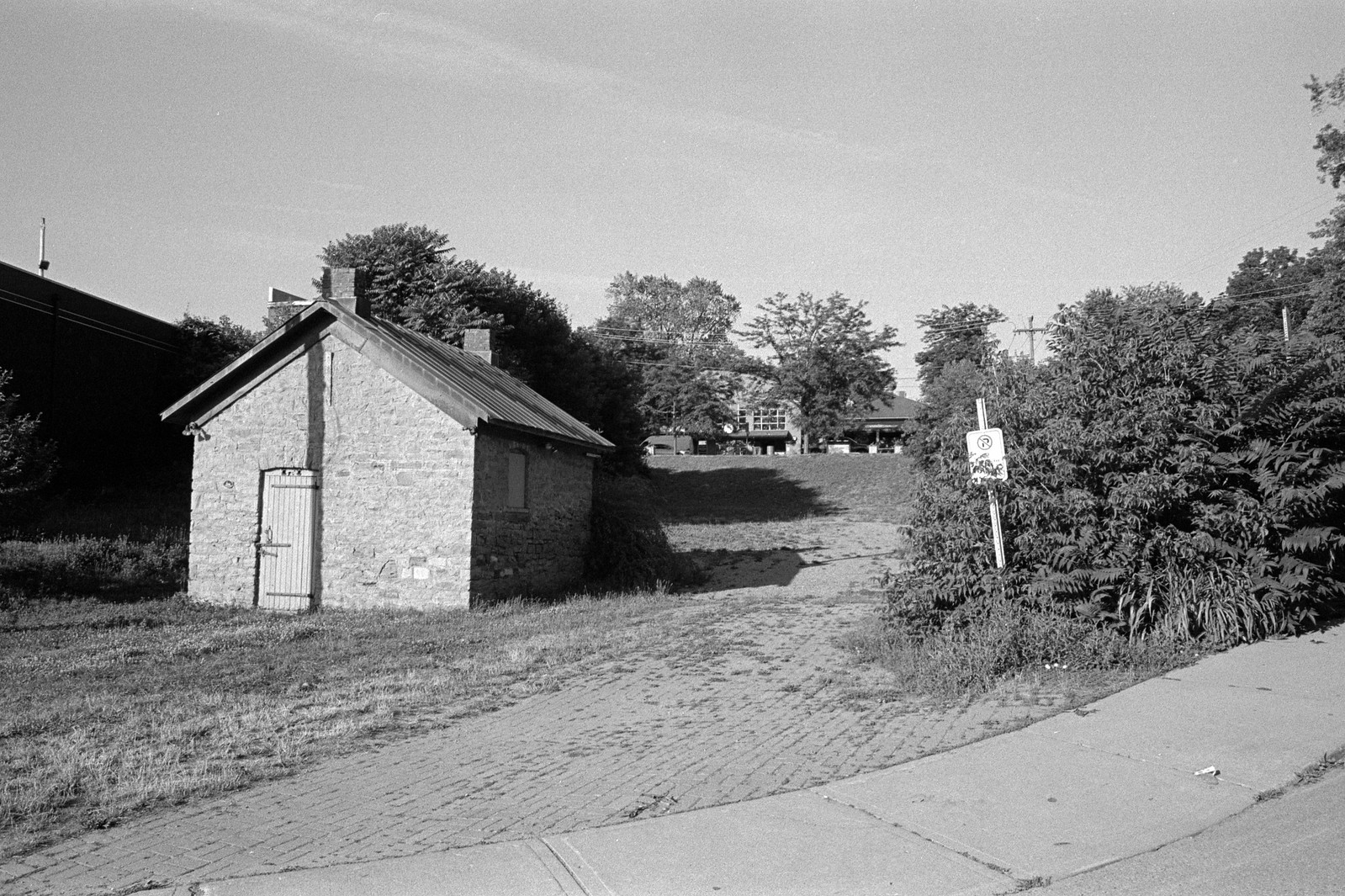
Minolta Maxxum 9 – Minolta Maxxum AF 28mm 1:2.8 – Kodak Tri-X 400 @ ASA-400 – Kodak D-76 (1+1) 9:45 @ 20C
Minolta Maxxum 9 – Minolta Maxxum AF 28-135mm 1:4-4.5 – Kodak Tri-X 400 @ ASA-400 – Kodak D-76 (1+1) 9:45 @ 20C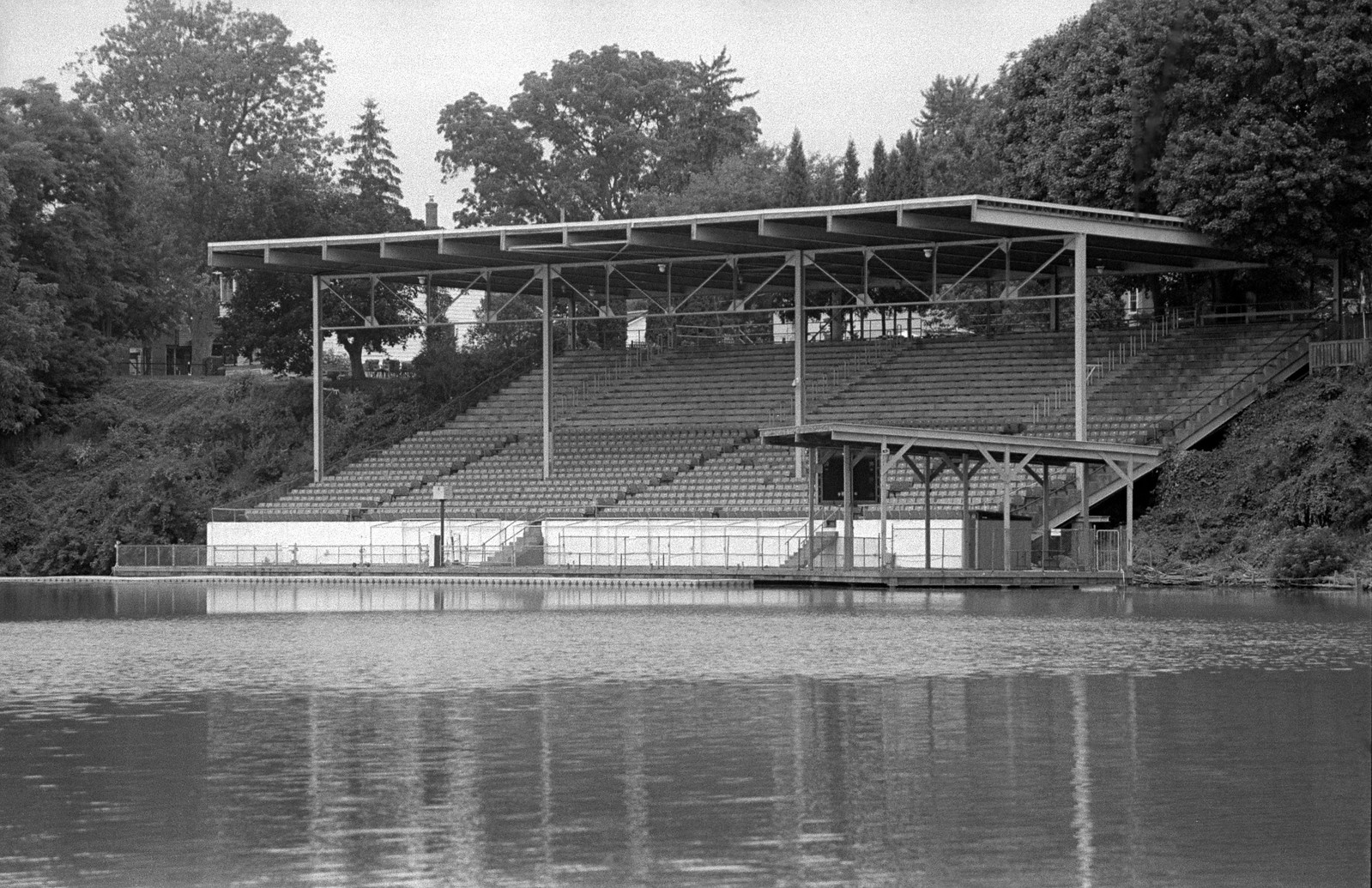
Minolta Maxxum 9 – Minolta Maxxum AF 28-135mm 1:4-4.5 – Kodak Tri-X 400 @ ASA-400 – Kodak D-76 (1+1) 9:45 @ 20C
The original terminus of the First Welland Canal was not on Lake Erie. Instead, it was onto the Lower Welland River, which traced its way out to the Niagara River and the small village of Chippawa. The plans called for two locks to bring ships in and out of the Welland Canal and onto the Welland River at the end of the Deep Cut. Between the construction of the locks and the Deep Cut a small shantytown to house the workers sprung up. The area would also be the site of a deadly bank collapse during the construction of the Deep Cut in 1828. The Shantytown took on a permanent community in 1829, taking the name Port Beverly, named for Sir John Beverly Robinson, Chief Justice of Upper Canada and earliest supporter of the Welland Canal from the Family Compact. All the early businesses were related to the Canal, taverns, boarding houses, stables and blacksmiths. Port Beverly’s place as the Canal terminus would be short-lived when the Canal terminus was extended out to Gravley Bay (later Port Colborne) in 1833, access to the Welland River was maintained at Port Beverly. In 1835 with the establishment of the first post office, the name of Port Robertson was taken. The access lock at Port Robinson remained when the Second Canal was planned, and the central location of Port Robinson made it the ideal spot for the Coloured Corps Headquarters. The Coloured Corps, a militia unit designed for policing the Canal’s worksites and was made up of mainly black men as enlisted although officers and NCOs were white. The Coloured Corps were not always welcomed (remember, black slavery ended in the British Empire in 1833); however, one local Anglican Priest allowed mixed services. The Corps was more than happy to fund the construction of a beautiful Anglican church in the community. The Second Canal improved size and traffic flow and encouragement of traffic onto and off of local waterways allowed Port Robinson to flourish. A couple of mills, a shipyard (using the old First Canal channels), a schoolhouse, churches, homes, stores, brought an influx of population outside of just those brought through by the Canal. By 1850 the community incorporated as a village and a swing bridge allowed for expansion on the other side of the Canal. At its peak, the population hit 600, and even after Merrittville (now Welland) was named the county seat in 1858, Port Robinson remained a bustling community along the Canal. While the Third Canal overtook the two older channels of the First and Second Canals and disconnected the Welland River from the Canal system, the 1880s weren’t bad for the community. Shipbuilding continued, which brought steel mills to the community. Although in the late decade a series of fires ripped through the commercial core destroying many of the old buildings. Ironically, many of the service boats that would go into the construction of the Fourth Canal came from the shipyards at Port Robinson and would be the last ships built in the town, with the lift bridge being the final element built. The new Canal bypassed the community altogether, and by the 1930s the population slowly slipped away. The last hit to the community came in 1974 when the ore carrier Steelton collided with the bridge that crossed the Canal. Having signalled too late for the bridge controller the raise the deck, the whole bridge collapsed into the Canal. The bridge never was replaced, although there were plans to build either a new bridge or a tunnel. Instead, the Seaway assigned a six-person pedestrian-only ferry. A year later Thorold annexed Port Robinson and Allanburg when it was incorporated as a city. Today, Port Robinson remains a divided community with road traffic having to cross either at Bridge 11 or the Thorold Tunnel and is a shadow of its former self. With a small commercial core and small to medium industries still present.

Minolta Maxxum 9 – Minolta Maxxum AF 35-70mm 1:4 – Kodak Tri-X 400 @ ASA-400 – Kodak D-76 (1+1) 9:45 @ 20C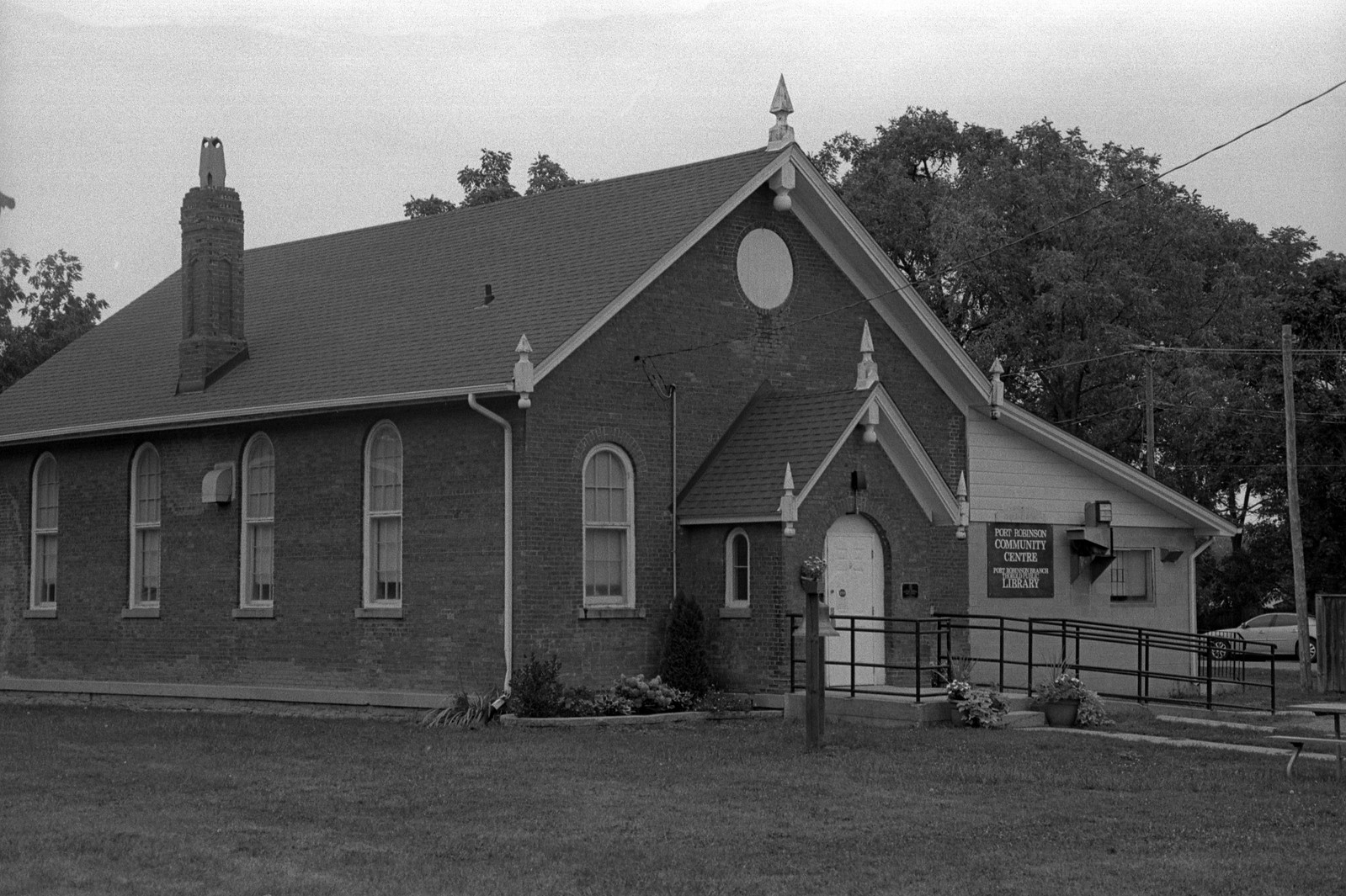
Minolta Maxxum 9 – Minolta Maxxum AF 28-135mm 1:4-4.5 – Kodak Tri-X 400 @ ASA-400 – Kodak D-76 (1+1) 9:45 @ 20C
Minolta Maxxum 9 – Minolta Maxxum AF 35-70mm 1:4 – Kodak Tri-X 400 @ ASA-400 – Kodak D-76 (1+1) 9:45 @ 20C
Minolta Maxxum 9 – Minolta Maxxum AF 28mm 1:2.8 – Kodak Tri-X 400 @ ASA-400 – Kodak D-76 (1+1) 9:45 @ 20C
Unlike most of the Port communities on the Welland Canal, Port Colborne is the only one to have been founded before the arrival of the Canal in a sense. The small shallow natural harbour and presence of flint made it an ideal spot for early settlement by the Neutral Nation (at least until their destruction in the 1650s), the shallow harbour attracted a small number of Loyalist Settlers in the 1780s, being close to the lake. The harbour being too shallow for most European craft and surrounded by marshland, the community was known as Gravley Bay did not do well in the shadow of the larger Petersville (later Humberstone) further inland. It wouldn’t be until 1831 that anyone would have even heard of the settlement when the Welland Canal began to push towards Lake Erie and the small community chosen as the Lake Erie terminus. The area proved a pain to work in, the floor of the shallow harbour was bedrock, and the marshes provided excellent breeding grounds for mosquitos and dirty water. Illness ran rampant throughout the shanty town the sprung up. While William Hamilton Merritt saw great potential in the latest port settlement, his wife was not as keen. Catharine’s journals described the community described the scene as marshland on either side of the Canal with a single white house up on a hill and a collection of rude shanties. Merritt, having a chance to survey the town to his specifications changed the name of the settlement to Port Colborne, honouring the Lieutenant-Governor of Upper Canada, Sir John Colborne. And naming all the streets after members of the Royal Family, except for Catharine Street, which he named after his wife as mentioned above. Merritt would go on to build a store and a post office. The community already supported a single grist mill and flaxseed mill that operated on cycled marsh water, but the new Canal offered them a touch more power. By 1835 the population sat at only 150, the post office offered three-days a week postal service (something even the larger Humberstone would not get until 1850). The Canal and a link to the Family Compact certainly held sway on many levels in Colonial operations. However, three factors restricted the early expansion of Port Colborne, lack of major water power, poor land, and no major urban centre nearby. Although the Canal did offer up some perks that brought hotels, taverns, boarding houses, and stables to the small settlement. As more people flocked the area, residents opened up local businesses such as a grocer, baker, and even a cobbler. The arrival of the Second Canal would only improve the fate of Port Colborne, fresh workers arrived, and the improved Canal would bring more traffic into the region along with an enlarged harbour. And even though the population stood only at 160 in 1850 the railroad soon arrived, the Buffalo & Lake Huron first followed by the Welland Railroad by the end of the decade (Grand Trunk would eventually gobble up both). The railroad recognized that ships would need to have their load lightened to travel the Canal, especially with Grain, Grand Trunk (by this point in control of Buffalo & Lake Huron) constructed a grain silo at the entrance to the Canal, the silo would offload a portion of the ship’s load of grain, transport it via the railroad where it would meet the ship at Port Dalhousie. The silo also introduced the milling, distilling, and brewing to the growing community. And it quickly supplanted Port Dalhousie in the milling business. The discovery of natural gas in the region would see further growth in the small community and giving it the needed edge to attract industry to the area. The jump in growth allowed Port Colborne to incorporate as a village in 1869. While shipbuilding proved important to the other port communities, Port Colborne never saw it as a major industry with the first yard opening in 1870. Most ship related operations in the area were towards the repair end of the spectrum. The village council saw more chances in attracting industrial manufacturing, the shallow water and rich sandy opened up the chance for glass production and the village council wasn’t above offering all sorts of bonuses to bring in the business. Tax exemption, free gas, cheap land, and other incentives. While many businesses were legitimate, others were more than happy to take the money and run. The 1880s brought plenty of tourists to the region; the shallow warm water and sandy beaches made it an ideal spot to get away from the bustle of urban living. The completion of the Third Canal and improved railroad access helped bring Americans and Canadians alike. Even private resorts such as the Humberstone Club were set up to attract the wealthy. The railroad got into the game early, donating a large portion of land to be set up as a public park with bathing houses, picnic shelters, and bandstands. By the end of the decade, Port Colborne was better known as a vacation spot than an industrial and Canal community. The old Grand Trunk silos unable to withstand the increase in wheat traffic, the Federal Government concern over getting Canadian Wheat to market opened a new 1,000,000 bushel silo in 1908, this, in turn, attracted larger flour mills and other ancillary industries such as bag making to the area, improvements in electrical generation and further discoveries of natural gas opened up cement works. By 1913 expansion into Northern Ontario yielded ore discovery and INCO opened up a nickel smelter and a steel mill joining the growing presence of heavy industry. The Canal acted as a natural barrier between the heavy industry and housing for blue-collar workers on the eastern side. At the same time, the wealth owners, managers, and tourists lived on the western side of the Canal. The Great War leaned into the industrial might of the Canal Corridor, and Port Colborne was no different than St. Catharines, Welland, and Merritton. And by 1917 had achieved town status. In 1919 due to poor storage and the explosive nature of grain dust the government silos suffered a major accident, debris from the detonation was found miles away. However, the silos were repaired and returned to service. The milling industry and the government silos were the key factors in maintaining Port Colborne as the Lake Erie terminus of the Canal when the Fourth Canal saw construction. However, the exit lock was moved further inland, between Port Colborne and Humberstone. While the Great Depression affected the town, it did not hit it as hard as other communities along the Canal. The only industry that took the hit would be the tourist industry with many resorts shutting down and heavy industry grabbing up prime real estate. And by the opening of the Second World War, the industry had returned to full force. By the mid-century Port Colborne absorbed Humberstone and in the 1960s the steel industry had a firm hold with Algoma Steel opening up a new mill in town, and by decades end Port Colborne was incorporated as a city. To celebrate the Welland Canal’s 150th Anniversary, Port Colborne launched a local festival, Canal Days, to highlight local talent and the Canal. Although the next two decades brought a sharp decline and closure of much of the heavy industry. The impact and environment damage saw the city launch a successful lawsuit to ensure proper environmental cleanup. The 2000s brought a serious effort for urban renewal including cleanup of the old sections of the Welland Canal and improvements in city parks and the downtown. While the Canal remains a key part of Port Colborne, tourism has also returned to the oldest continuously operating ports on the Canal.

Minolta Maxxum 9 – Minolta Maxxum AF 28mm 1:2.8 – Kodak Tri-X 400 @ ASA-400 – Kodak D-76 (1+1) 9:45 @ 20C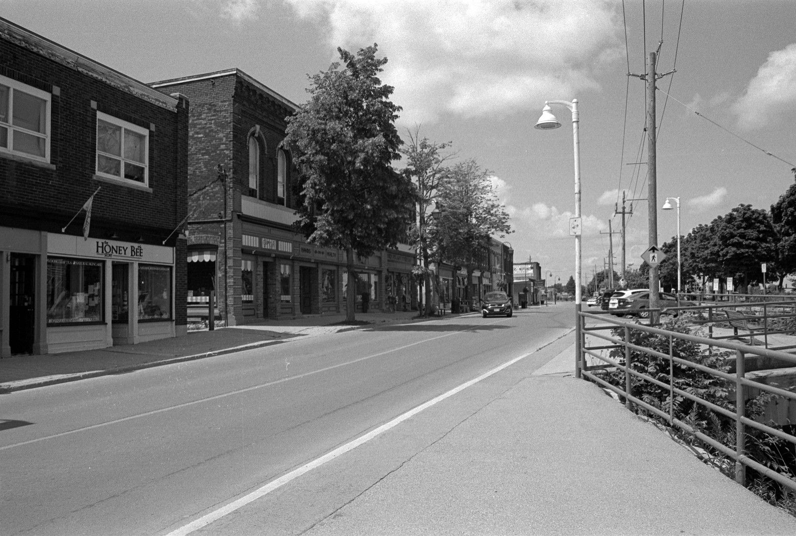
Minolta Maxxum 9 – Minolta Maxxum AF 28mm 1:2.8 – Kodak Tri-X 400 @ ASA-400 – Kodak D-76 (1+1) 9:45 @ 20C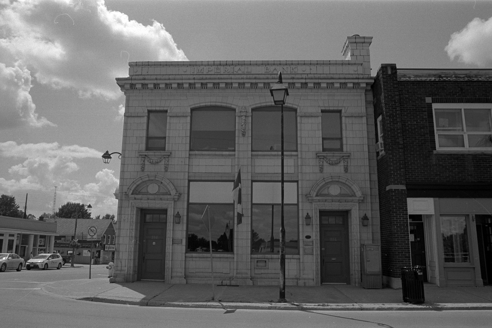
Minolta Maxxum 9 – Minolta Maxxum AF 28mm 1:2.8 – Kodak Tri-X 400 @ ASA-400 – Kodak D-76 (1+1) 9:45 @ 20C
Minolta Maxxum 9 – Minolta Maxxum AF 28mm 1:2.8 – Kodak Tri-X 400 @ ASA-400 – Kodak D-76 (1+1) 9:45 @ 20C
The youngest and perhaps most boring port the on the Welland Canal in Port Weller. Port Weller was not the first settlement along the Ten Mile Creek. Two small settlements were established in the 1780s. The first being Lower Ten, the second Upper Ten, although the latter is better known as Homer. Both communities were primarily rural, small settlements for local farms. Homer being the larger of the two, creating a small town centre with a blacksmith and general store. The location on the water offered up a small beach that proved more popular to locals than tourists who were much happier in Port Dalhousie and Port Colborne. Being located near the far larger Port Dalhousie and St. Catharines, the communities saw little growth and little influence from industrial growth. However, the development of the fruit belt did attract some growth. Ten Mile Creek became the favourite choice of Major John L. Weller, the engineer in charge of the new Canal project. When it became the selected terminus for the new Canal, much of the land was quickly bought up by the Government, and many of the small farms and the two communities were quickly swept aside. Port Weller would be officially established in 1913. Port Weller, named for Major Weller, would be laid out in such a way to put an industrial section to one side of the Canal and the residential to the other. Parks, homes, schools, and churches were all laid out. While the residential side filled in quickly, the industrial side failed to attract new businesses, and the Government would build a massive storage facility that would transform into the Port Weller Drydocks. Port Weller only enjoyed a short period of municipal independence as it to was swallowed up by St. Catharines when it was incorporated as a city.

Minolta Maxxum 9 – Minolta Maxxum AF 70-210mm 1:4 – Kodak Tri-X 400 @ ASA-400 – Kodak D-76 (1+1) 9:45 @ 20C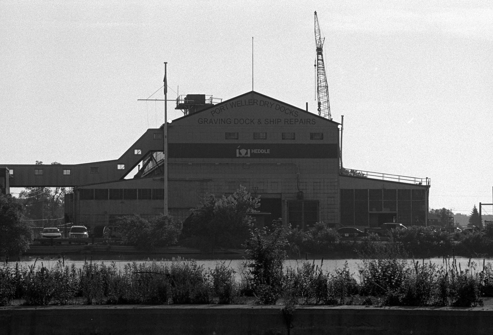
Minolta Maxxum 9 – Minolta Maxxum AF 70-210mm 1:4 – Kodak Tri-X 400 @ ASA-400 – Kodak D-76 (1+1) 9:45 @ 20C
Mamiya m645 – Mamyia-Sekor C 35mm 1:3.5 N – Rollei Superpan 200 @ ASA-200 – Blazinal (1+100) 60:00 @ 20C
Minolta Maxxum 9 – Minolta Maxxum AF 70-210mm 1:4 – Kodak Tri-X 400 @ ASA-400 – Kodak D-76 (1+1) 9:45 @ 20C
Today, only Port Colborne remains an independent entity; all the others are now part of larger municipalities. But don’t let that stop you from visiting them; in fact, the locals love to see new faces in their communities. Port Colborne is a thriving tourist town with plenty to see along the central Canal in the historic downtown; you can also view Lock 8 from a park situated between the historic downtown and the former town of Humberstone. The downtown offers lots of local restaurants and even a craft brewery. And Canal Days are worth attending and are held over the August Long Weekend. Port Robinson is a sleepy community which is easily overlooked. But you can take in the historic St. Paul’s Church, recently saved from demolition along with the 1863 Brick School House. There’s nothing left of Bridge 12, except a great view of the original Deep Cut from the edge of Bridge Street. I also recommend eating at Bridge 12 Pub, the owner is friendly and I’ve enjoyed a meal and a pint there on a couple of occasions. My favourite old port remains Port Dalhousie, while it still needs some help, it’s a great spot to go down to the water, catch a ride on the carousel walk through the historic downtown. Be sure to grab a pint and a meal at the Kilt & Clover and see what’s brewing at Lock Street Brewing. If that’s not your thing, there’s a Balzac’s Coffee Shop and a great spot to get ice cream. Another exciting part of Port Dalhousie is the presence of a memorial to the Nuclear bombings of Hiroshima and Nagasaki in Rennie Park. And if you missed it, with a month until Christmas if you’re thinking of ordering a copy of the book, The Canal, now is the time so that it arrives in time!
Written With Files From
Jackson, John N. The Welland Canals and Their Communities: Engineering, Industrial, and Urban Transformation. University of Toronto Press, 1997.
Styran, Roberta M., and Robert R. Taylor. This Colossal Project: Building the Welland Ship Canal, 1913-1932. McGill-Queen’s University Press, 2016.
Styran, Roberta M., and Robert R. Taylor. This Great National Object: Building the Nineteenth-Century Welland Canals. McGill-Queen’s University Press, 2012.
Styran, Roberta McAfee, and Robert R. Taylor. Mr. Merritt’s Ditch: a Welland Canals Album. Boston Mills Press, 1992.
Jackson, John N., and Fred A. Addis. The Welland Canals: a Comprehensive Guide. Welland Canal Foundation, 1982.
Styran, Roberta M, et al. The Welland Canals: the Growth of Mr. Merritt’s Ditch. Boston Mills Press, 1988.