Every story needs a beginning, and Oakville’s story starts here, with a creek. Without the creek, there would have been no Oakville. Survival of life depends on water; without it, nothing could live. And water provided not only for the natural world but also humanity. To drink, wash, and travel through the dense backwater than was Ontario. And it also provided the earliest power of the early industries.
Formed during the last great ice age and the retreat of the same glacier that began the great lakes and the Niagara Escarpment, the nameless creek meandered from the escarpment into one of the many lakes formed. The earliest known human settlement along this unnamed creek dates to 9000 BCE. These humans wandered the dense Carolinian forests, following animals they hunted and used for food and clothes. They were leaving only small traces of their presence. By 500 CE, the Wendat, an Iroquoian-speaking group, settled along the creek’s banks. They travelled along the shallow-bottomed creek and used its water to drink, wash and farm. Growing crops, trading with others and forming small settlements. The beaver wars spawned from Europeans trying to expand their access to the hot commodity of the 17th Century in Europe. The Wendat, though peaceful, were destroyed by the Haudenosaunee from the south. And as time turned, by the 1700s, the Ojibwe Anishinaabe pushed the Haudenosaunee out and claimed the area. The Anishinaabe first named the creek, calling it niizhozaagiwan, or roughly translated as ‘having two outlets’, an apt descriptor as the creek mouth was separated by a gravel bar as it flowed into the lake. The Jesuit missionaries who passed through the area also called the creek River de Gravois, or Gravelly River, because of the shallow gravel bottom. When British agents arrived in the early 19th Century, they took a different approach, giving the name Sixteen Mile Creek as its mouth lay sixteen miles (25.7 kilometres) from the western mouth of Lake Ontario. The creek became the core of many settlements that used it mainly to the power grist mill to support agriculture or sawmills to exploit the vast timber resources. Both for export and to construct the first communities and support the shipyards. And, like many waterways, it became clogged with waste. So in the late 20th Century, the idea of conservation of the creek valley became the forefront. In Oakville, the Lion’s Club spearheaded the effort securing the purchase of 2,500 acres of the creek valley, running from Upper Middle Road in the south to north of Dundas Road. Through their efforts, the valley walls were stabilised, tree growth encouraged, and a series of trails were cut through the valley. The results speak for themselves as a beautiful trail that feels completely separated from the world today. The tall trees harken back to the days before humans paved over the land, and it is home to many different plants, trees, and animals. Oakville has also installed several information plaques that share the area’s colonial and indigenous histories. Today, Lion’s Valley Park offers a space of peace for walking, picnicking and photography.
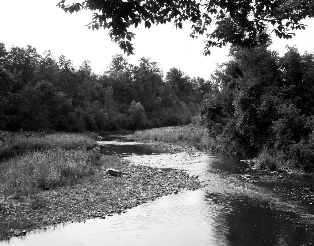
While most people know the main part of Lion’s Valley Park around Dundas Road, I recently discovered the lesser-known and much quieter southern section. Accessed off Upper Middle Road, this is a bit more involved to get down into the valley as you have to park above and hike down into the valley floor. Then followed the trail to the end; I found this beautiful bend in the creek, where you can see the iconic creek walls, but most importantly, there’s no sign of the modern town poking up above the valley. Using my 125mm lens and metering of the threes at the far bank, I under-exposed by one stop to reign in the highlight detail. But shooting at high noon made it impossible to easily recover the sky details, although I was more concerned with ensuring my shadow details remained visible. The creek also had tiny movement, only a bit on the lower right side.