The term township in southern Ontario is a bit of a throwback. It’s often referenced within a historical context and is often seen in the province of Quebec (The Eastern Townships) or further north in Ontario. But the township formed a core of the colonial survey of Upper Canada as one of the subdivisions of the province for settlement purposes.
The province was subdivided for several purposes during the colonisation of Upper Canada. The coordination of the provincial militia, representation in the colonial parliament, and the division and sale of land. After the province was the district, districts were large geographical areas and were often tied to the origination of the local militia units. Districts are even less known as townships because they were dissolved in the 1850s. Within each district were several counties, and each county’s representatives were elected to the Legislative Assembly of the Colonial Parliament. The counties were then divided into townships. To keep track, Oakville sits in the Gore District, Halton County, Trafalgar Township. Gore District is thought to be named for Francis Gore, the Lieutenant-Governor of Upper Canada from 1806 to 1817. However, he left Upper Canada from 1811 to 1815 when General Sir Isaac Brock acted as Governor under the President of the Executive Council. Halton County is named for Gore’s secretary, Major William Halton, who, by all accounts, spent very little time in Upper Canada. The land that formed most of Halton County was purchased in 1805 under the Head of the Lake Purchase or Treaty 14 from the Mississaugas of the Credit First Nation. Four townships were drawn up from Halton County, Nelson, Trafalgar, Nassagaweya, and Esquining. As you can tell, two of the names relate to the iconic Battle of Trafalgar in 1805, where Horatio Nelson lost his life. Thomas Street would be retained to survey Trafalgar Township. On paper, survey work was done in a neat grid, all straight lines with no allowance for variances in the landscape. In reality, being an all-manual process, consecutive lines were rarely straightforward, and the landscape did not confirm the idea of British straight lines. Each township had a single baseline where concession roads were running off; between these concessions, 200 acres were marked off, with every fifth lot being designated as a side road that ran perpendicular to the concession road. Neat and orderly on paper, far more organic in reality. Lots were either purchased or granted to individuals and could be subdivided. Some lots were farmed in their entirety others were further surveyed into settlements. Lots with access to water were prized as the owner could build a water-powered mill. Lots on major roads would be ideal for building taverns and inns for travellers to rest. Often small settlements would spring up at intersections around a mill or an inn. Other industries and commercial stores followed. Postal service often gained an official name for these settlements. And many would join together as a form of local government. When the idea of districts was dropped, counties took over many items once done at the district level; this included the administration of schools and militia units. In 1857, improvements in the municipal governments granted town status to Oakville and Milton, the two major urban centres in the township, allowing the formation of a town council and election of mayors. Counties also took over the administration of courts and land registries (Milton beat out Oakville by building a courthouse first). The township as an organisation continued until 1962, when further amendments to the local government dissolved any remaining townships and transformed some counties into modern Regional Municipalities. The surviving settlements in the four townships were absorbed into the major urban centres of Milton, Burlington, and Oakville. It also saw the creation of Halton Hills.
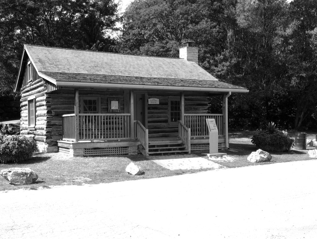
The big question was how to represent a township in an image. While I did aim to capture many of the former settlements of Trafalgar Township, some no longer have anything left to capture, having been wiped off the map. Then it hit me, Lyon’s Cabin. The exact date of construction varies on what you read; some say 1810, while others put it more in the 1820s. Either way, the cabin is a fine surviving example of what an early settler cabin would have looked like in Trafalgar Township. Originally part of a settlement named Vernerville, it was lost and rediscovered during the construction of the modern Oakville town hall. It was relocated to Shipyard park and restored in 2014. Thankfully it has nice clean sight lines, so grabbing my 150mm lens, I metered for the shadows under the front porch and under-exposed by a stop. Again the highlights were burned out because of the near overhead sun, but it is only pavement and not that important overall.