While the water provided a fast and efficient means of travel, southern Ontario only had a small fraction of territory easily accessed by navigable waterways before creating a system of canals. Colonisation roads were among the earliest infrastructure projects by British authorities to help move troops around the newly created province of Upper Canada and later settlers to head deeper into the province’s backwater. And while Sixteen Mile Creek provided a source of power and drinking water, the movement of people was more easily done through a system of roads. And the earliest road was Dundas Road.
The British were a people of order; they needed things to be straight and squared away. And the ancient forests were crossed by winding trails formed by animals or the Indigenous people moving across the territory. But these tracks were only those that followed the movements of the land winding and tracing their way through the forests. The first governor of Upper Canada, Sir John Graves Simcoe, ordered a new military road run from Burlington Bay to the planned location of London, where Simcoe aimed to create a colonial capital. Originally called the Governor’s Road, Simcoe named Dundas after his friend Henry Dundas. Dundas has recently come under fire for his efforts to push back the end of black slavery within the British Empire. The road was cut from the wilderness, with the work being done by an irregular force, the Queen’s York Rangers starting in 1793. Work began on a second branch that split off in the community of Dundas to head east towards the ultimate colonial capital of York in the early 19th century, which was quickly finished during the first year of the Anglo-American War of 1812 to provide a military supply road to the Niagara frontier. This second branch would soon become a significant east-to-west road that assisted in the post-war movement of settlers across Upper Canada. And along this road, some of the earliest settlements would spring up, often centred around an Inn or Mill. Within the modern confines of Oakville, the road provided a base point for the surveys of the newly opened region. The biggest problem was the sixteen-mile creek valley; the steep walls presented a danger to travellers on foot, horseback or stagecoach. The 1830s bridged the creek itself, and the road was the scene of William Lyon MacKenzie’s escape in the aftermath of his failed uprising. An improved metal bridge was built in 1885. But the 20th century brought about the arrival of the automobile, and the dirt roads of the previous century proved a hazard to the new horseless carriages. The Ontario government began a concentrated effort to modernise Ontario’s roads and form a system of highways. By 1921 sections of the original Dundas Road had been realigned and rebuilt to form the backbone of Highway 5, and a high-level bridge was constructed to make the passage over the creek valley safer. And by 1930, the entire length from Toronto to Paris was paved. Despite the Middle Road (Queen Elizabeth Way) opening in 1936, Highway 5 retained its importance as a surface route, with 144 kilometres of uninterrupted roadway. Downloading began in the 1950s, with lengths of the highway being turned over to local governments for maintenance responsibilities. As the population grew, the road saw improvements, realignments and enlargements, primarily through the Greater Toronto Area in the 1970s. The most extensive download came in the 1990s when the province cut the official length of the highway down to the modern distance of 73 kilometres, with many communities renaming the highway Dundas Street. In Oakville, the original 1921 bridge was replaced in 2011. Today, the modern Dundas Street does not accurately represent the original colonial road. Like other roads in Ontario, it has been realigned and, in many cases, renamed. Sections now follow Highway 5, County Road 99 (Governors Road) and Highway 8 in many places. But the route still provides a thoroughfare through the GTA and continues to grow and change as the years pass.
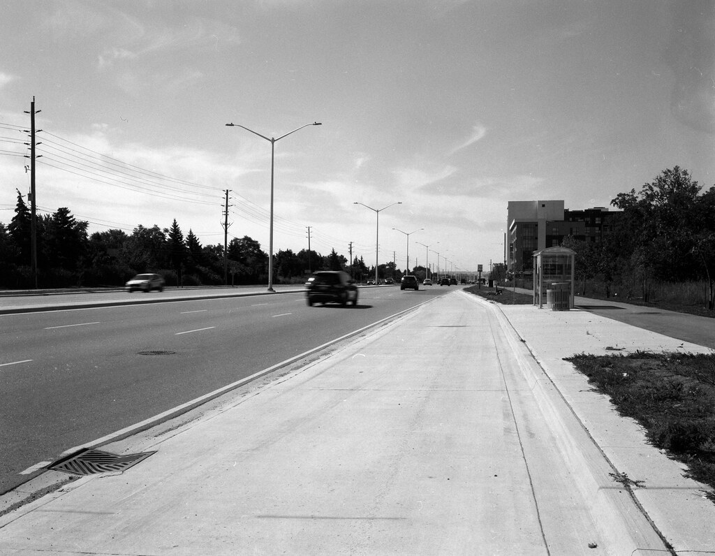
Concentrating my project within the confines of the modern community of Oakville meant that I could not go and find parts of the original Dundas road, especially in Oakville, where the road has been under constant improvement since the 20th century. Instead, I focused on the intersection of Sixth Line and Dundas as it was once a stop along the Dundas Stagecoach route. But not overly exciting, but no spot along the modern route is inspiring. Working with what I had, I went with the 125mm lens and angled my camera slightly to use the centre median and the road edge to act as an off-centre convergence. I took an average meter from the sky and the trees on the left side, wanting more detail in the skies than the shadows as the whole scene was under the high-contrast overhead light. While some shadow details would have been nice, I’m happy with the exposure as the light standards are not lost, and there is some movement in the cars.