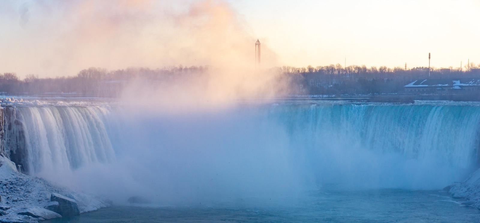
When it comes past projects related to history which I have written, the foundations of the events which I planned to explore are relatively modern happening some three to two hundred years in the past. A small drop in the bucket of the history of our planet. But when it comes to the Welland Canal, the foundations of that canal take place in the dark distances of prehistory. The need for a canal across the Niagara Peninsula is related to a massive limestone cliff that cuts across the modern province of Ontario known today as the Niagara Escarpment. Today the cliff runs from the Niagara River in the south to Georgian Bay in the North. In the south, a river runs between two of the great lakes, and over that high cliff runs a waterfall. The cliff, river, waterfall, and great lakes can trace their origins back 11,000 years. The retreat of the Wisconson glacier and ice melt deposited water in several ancient bodies of water, Lake Chicago, Lake Iroquois, and the Champlain Sea as the water retreated a high flow of water cascaded down the limestone cliff near the modern community of Queenston. The years of flowing water wore away at the cliff and rock; a deep gorge clawed its way west forming an impassible barrier.
Sony a6000 + Sony E PZ 16-50mm 1:3.5-5.6 OSS
The first humans in the area called the area the neck, or in their language O-ne-aug-ga-rah. This is the root of our current term Niagara which comes from the language of the Mohawk nation in approximately 1820. These first humans to view the great falls arrived around 1300 CE. These people rely on the river for swift travel between settlements for both trade and war, the great falls, however, keep them from moving too fast. They take to the ancient forests on well-worn trails to move their watercraft and cargo on foot. The people who occupied the area stood neutral between the conflicts between the civilisations to the north and the south, earning the name Atiquandaronk or the Neutral Nation. The Neutral Nation fell in the mid-1600s during a violent period that saw the Iroquois nation invade, enslaved, and eradicate the Neutrals in the region. The French were the first European to reach in the region; legend says that Samuel de Champlain the great French explorer was the first European to witness the falls. Surviving journals state that men under his command witnessed the falls in the early 1600s. The Jesuit order soon followed, aided by the peoples who now occupied the area. What drove the French further into the American continent? The Fur trade and they realised that they needed a way around the magnificent falls. At the mouth of the Niagara River into Lake Ontario, they established their first permanent settlement a trading post known as Fort Niagara, above the falls a smaller post, known as Fort Little Niagara. Linking these two posts a portage road where men would carry or cart their precious cargo overland before loading them back into a second set of boats at their destination.

Rolleiflex 2.8F – Carl Zeiss Planar 80mm 1:2.8 – Lomography Potsdam 100 @ ASA-100 – Pyrocat-HD (1+1+100) 10:00 @ 20C
The French-Indian War tipped the balance of power into the favour of the British. In 1759 British forces laid siege to and captured Fort Niagara. In their retreat, the French destroyed Fort Little Niagara. To secure the portage road, the British constructed Fort Schlosser above the great falls. The first recorded visual record of the falls came nearly a decade later in 1769 when Captain Thomas Davies of the Royal Artillery painted the falls. By the late 18th century the falls were fairly close to where they cascade over the edge today. Despite the American revolution the British hold onto the territory and the two forts giving them up only at the turn of the century under the terms of the Jay Treaty. A new eighteen-kilometre portage route was then carved between the small village of Queenston at the base of falls and Chippawa at the crest. As before lake boats unloaded their cargo at Queenston, from their ox-drawn carts would take the cargo up the escarpment provided the road remained passable, and then the cargo reloaded onto new boats in Chippawa. The whole process took a day or two. A Queenston business owner, Richard Hamilton, saw the need for a more natural way to move cargo across the Peninsula. In 1799 Hamilton petitioned the Provincial government to fund the construction of a water channel from Queenston to Chippawa. A feat not efficiently completed as no natural waterway existed between the two settlements. The pension, unsurprisingly, would be turned down by the parliament. That would be at least until war again pitted the Empire of England and the fledgeling United States again brought the idea of a canal to bypass the venerable river borders to a forefront.
Pacemaker Crown Graphic – Schneider-Kreuznack Angulon 1:6,8/90 – Kodak Tri-X Pan (320TXP) @ ASA-250 – Kodak Xtol (1+1) 7:45 @ 20C
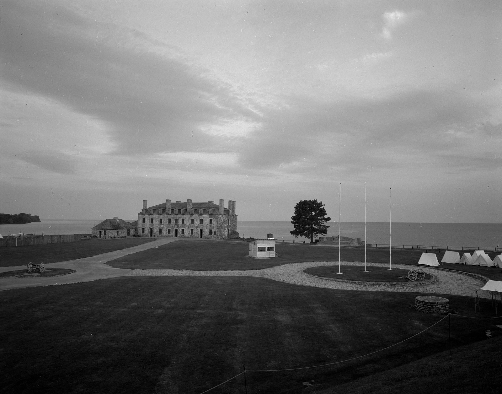
Today Niagara Falls is much further back from when the first canal saw construction in 1829 and is not as much of a concern to the economy today thanks to the Welland Canal. Instead, Niagara Falls both on the Canadian side and the American side of the river is a major tourist draw, and millions of people gather along the edge of the massive gorge to this day. Not only do they come for the natural beauty but the major tourist district of Cliffton Hills on the Canadian side and the darker American side. A boardwalk and cable car allow you to see the river bed in safety and the sheer size of the gap that bridges span today. While you can still walk the old portage road between Queenston and Chippawa, it is far easier to drive the section using the Niagara Scenic Parkway not only is it faster it’s a touch safer. Fort Niagara still stands in Youngstown, New York with many of the original French, British, and American buildings still standing and hosts events about the fort’s role in the French-Indian War, American Revolution, and the War of 1812 presented at the site. Fort Schlosser, however, is long gone, the original site now home to massive valves for the power generation that takes place along the Niagara River. The only surviving structure a chimney is relocated to a traffic circle closer to Niagara Falls, New York. The first civilisations that occupied the area are remembered if only in passing with memorials to their role in the Anglo-American War of 1812 at Queenston and Youngstown.
Written With Files From
Jackson, John N. The Welland Canals and Their Communities: Engineering, Industrial, and Urban Transformation. University of Toronto Press, 1997.
Styran, Roberta M., and Robert R. Taylor. This Colossal Project: Building the Welland Ship Canal, 1913-1932. McGill-Queen’s University Press, 2016.
Styran, Roberta M., and Robert R. Taylor. This Great National Object: Building the Nineteenth-Century Welland Canals. McGill-Queen’s University Press, 2012.
Styran, Roberta McAfee, and Robert R. Taylor. Mr. Merritt’s Ditch: a Welland Canals Album. Boston Mills Press, 1992.
Jackson, John N., and Fred A. Addis. The Welland Canals: a Comprehensive Guide. Welland Canal Foundation, 1982.
Styran, Roberta M, et al. The Welland Canals: the Growth of Mr. Merritt’s Ditch. Boston Mills Press, 1988.